The map
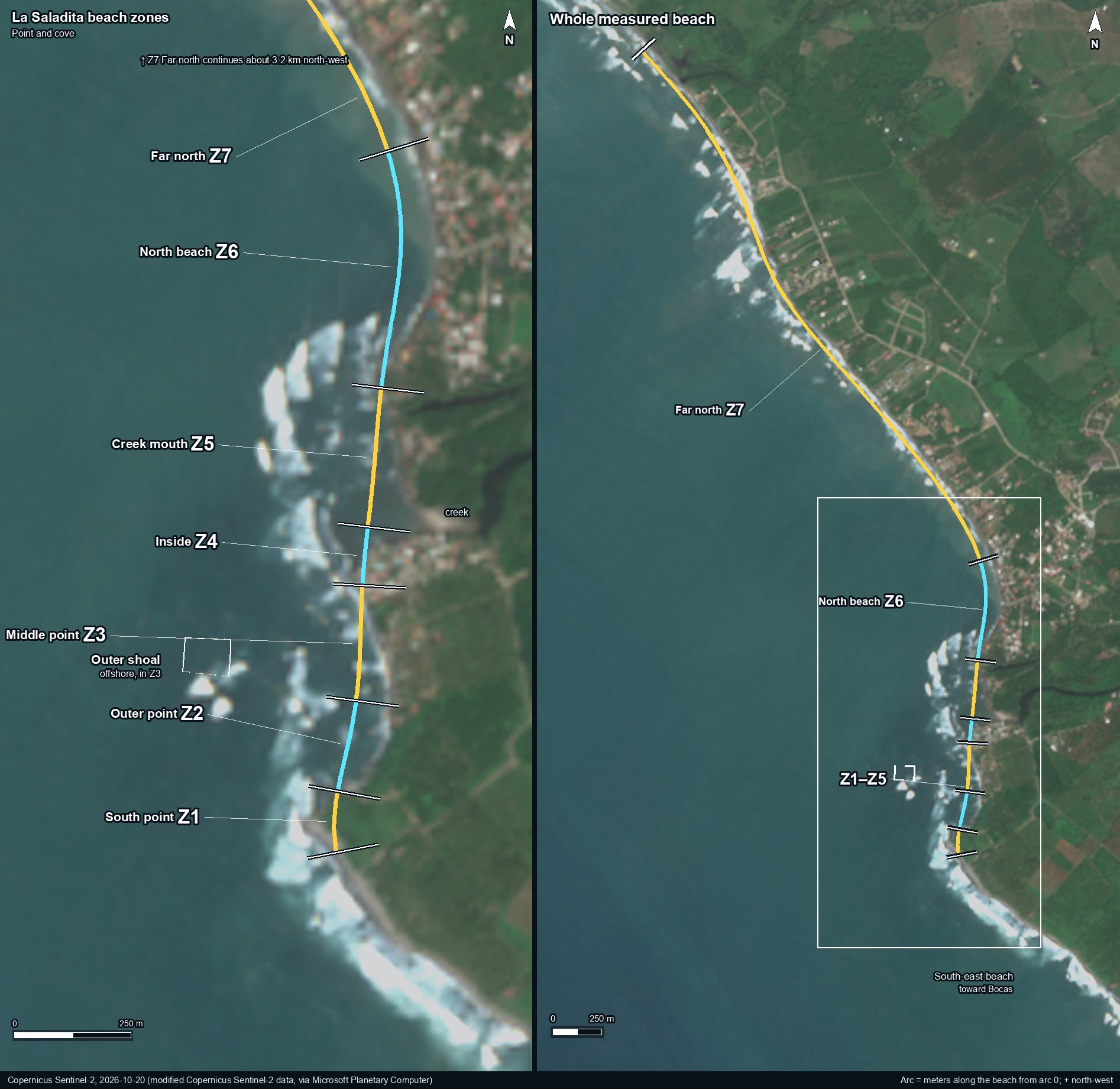
The zones
| Code | Name | Arc (m) | Length | South end (lat, lon) | North end (lat, lon) | What is there |
|---|---|---|---|---|---|---|
| Z1 | South point | −1,100 to −975 | 125 m | 17.83036, -101.77038 | 17.83148, -101.77037 | The rocky tip where the wave starts. The point tip (about arc −1000) breaks on the smallest swell. |
| Z2 | Outer point | −975 to −775 | 200 m | 17.83148, -101.77037 | 17.83325, -101.77003 | The first stretch of the ride: the gap just past the point (−950 to −900) and the outer section (−850 to −800). |
| Z3 | Middle point | −775 to −525 | 250 m | 17.83325, -101.77003 | 17.83551, -101.76993 | The middle gap (−750 to −550), the stretch that needs the most swell to break. The outer shoal sits offshore here. |
| Z4 | Inside | −525 to −400 | 125 m | 17.83551, -101.76993 | 17.83663, -101.76984 | The inner section of the ride, south of the creek; it breaks on small swell. |
| Z5 | Creek mouth | −400 to −100 | 300 m | 17.83663, -101.76984 | 17.83933, -101.76961 | Where the creek reaches the beach (about arc −350 to −300; the mouth moves). The lowest sand in recent years sits just north of it (−250 to −200). |
| Z6 | North beach | −100 to +425 | 525 m | 17.83933, -101.76961 | 17.84402, -101.76956 | The north end of the cove, where the wave ends and the shore turns to face the open sea. |
| Z7 | Far north | +425 to +3,600 | 3,175 m | 17.84402, -101.76956 | 17.86745, -101.78633 | The open beach north-west of the cove, to the end of the measured transects (about 3.2 km), toward La Unión. |
Offshore and outside the zones
| Code | Name | Arc (m) | Length | South end (lat, lon) | North end (lat, lon) | What is there |
|---|---|---|---|---|---|---|
| Z3 | Outer shoal (offshore, in Z3) | −750 to −650 | 300–400 m offshore | 17.83406, -101.77327 | A shallow spot 300 to 400 m offshore of Z3 (arc −750 to −650). In dry-season satellite images most of the middle-gap whitewater sits here. | |
| none | South-east beach | −3,000 to −1,100 | 1,900 m | 17.81937, -101.75683 | 17.83036, -101.77038 | Outside the zones: the open beach south-east of the point, toward Bocas and Troncones. The shoreline study uses its far part (arc −3000 to −1500) as a control beach. |
Old terms and their zone
| Term | Zone | Arc (m) |
|---|---|---|
| south point | Z1 | arc −1100 (start of the wave) |
| point tip | Z1 | about −1000 |
| gap near the point, gap 1, point gap | Z2 | −950 to −900 |
| outer section, outer point | Z2 | −850 to −800 |
| middle gap, main gap, gap 2 | Z3 | −750 to −550 |
| outer shoal, the shallow spot offshore | Z3 (offshore) | −750 to −650, 300–400 m out |
| inside, inner section (of the ride) | Z4 | −500 to −400 (the inshore water at −600/−550 sits where Z3 meets Z4) |
| creek mouth, inner cove, low spot | Z5 | mouth about −350 to −300 (it moves); lowest sand −250 to −200 |
| inside of the wave, around the creek mouth | Z5 | −400 to −125 |
| inside of the cove, cove frontage | Z6 | −100 to +425 (the zone) |
| north end of the cove, armored frontage, inside-of-break frontage | Z6 | −100 to +425 (the zone) |
| NW flank (just past the armored stretch) | Z6 | −100 to +425 (the zone) |
| unwalled beach just north-west, 0.45–1.15 km NW | Z7 | +450 to +1150 |
| the stretch about 1.4 km north-west | Z7 | about 1.4 km north-west; the zone runs +425 to +3600 |
| far NW control, ≥ 2.2 km NW | Z7 | +2200 to +3600 |
| the cove (the wave stretch), the break | Z1–Z5 | −1100 to −125 |
| Bocas side, SE control, toward Troncones | outside (South-east beach) | −3000 to −1100 |
How the zones are defined
The frame is the one the shoreline study already uses: 151 shore-normal transects, every 50 m (every 25 m near the north end of the cove), from arc −3000 to +3600. Arc 0 sits at the south end of Z6; distances grow toward the north-west and fall toward the point. Each zone runs from its first arc value up to, not including, the next zone's first value, so every transect belongs to exactly one zone.
The edges follow the beach and the ride, not any building: the point tip, the gap near the point and the outer section, the middle gap, the inner section, the creek mouth, the north end of the cove, and the open beach beyond it. The creek mouth moves; OpenStreetMap draws it at about arc −365 and the shoreline study puts it at about −300, both inside Z5.
Zones describe location only. They do not name, number or date any property, wall or deck. The codes are fixed: a new zone gets a new code, and no code is reused.
Machine-readable key: zones.json (codes, English and Spanish names, arc ranges, coordinates of each edge, the outer shoal outline).
Sources: zone frame from the La Saladita shoreline study (151 transects; Is the wave changing?); section and gap positions from Where the point breaks; creek line © OpenStreetMap contributors (ODbL); image: Copernicus Sentinel-2 L2A, 20 October 2026 (contains modified Copernicus Sentinel-2 data), via Microsoft Planetary Computer.
Cite as: “Beach zones at La Saladita”, La Saladita Field Guide, lasaladita.com/findings/beach-zones/, 2026-10-28.